39, Muswell Avenue, N10 2EB
Property data
- Sale history
- Internal area
-
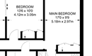
- 333 square metres (sqm)
- 3,584 sq feet (sqft)
- £ per square metre / foot
-
- £5,090 per sqm or £473 per sqft, based on the Feb 2007 sale.
- For context, homes in New Southgate are selling for between £6,540 and £9,080 per square metre . See the scatter plot of sales in Muswell Avenue or the wider analysis of New Southgate N10-2 housing market.
- Floor plan
- To view the floor plan please login or register
- Bedrooms
- 6
- Type
- Semi-detached
- Council tax band
- H
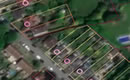
- Freehold boundaries
Archived listings

Planning
November 2008
- Type:
- Heritage application - conservation issues and listed buildings
- Status:
- Status not known
- Address:
- 39 Muswell Avenue Londo
- Description:
- Conservation Area Consent for demolition of existing fence, trellis, masonry to the boundaries of property and erection of low level brick walls, new piers to pedestrian entrance, vehicle entrance and new hardwood fence / trellis.
November 2008
- Type:
- Full and householder planning application
- Status:
- Status not known
- Address:
- 39 Muswell Avenue Londo
- Description:
- Demolition of existing fence, trellis, masonry to the boundaries of property and erection of low level brick walls, new piers to pedestrian entrance, vehicle entrance and new hardwood fence / trellis.
June 2008
- Type:
- Full and householder planning application
- Status:
- Application withdrawn before a decision was taken
- Address:
- Outside 39 Muswell Avenue Londo
- Description:
- Erection of Royal Mail pouch box.
November 2007
- Type:
- Full and householder planning application
- Status:
- Status not known
- Address:
- 39 Muswell Avenue Hornsey Londo
- Description:
- Use of flat roof over rear ground floor extension as a roof terrace and installation of railings.
Inspections
March 2011
- Summary:
- Energy performance certificate grade E - inspected on 2011-03-01
- Reason for EPC:
- rental (private)
- Tenure:
- Private rental
- Property type:
- End-Terrace House , has 10 habitable rooms. Estimated year built before 1900
- Area:
- 333 sqm (3,584 square foot) total internal area
- Comments:
- Walls: Solid brick, as built, no insulation (assumed). Roof: Pitched, 100 mm loft insulation. Heating: Boiler and radiators, mains gas.
February 2010
- Summary:
- Energy performance certificate grade F - inspected on 2010-02-12
- Reason for EPC:
- marketed sale
- Tenure:
- Owner-occupied
- Property type:
- End-Terrace House , has 9 habitable rooms. Estimated year built 1900 to 1929
- Area:
- 352 sqm (3,789 square foot) total internal area
- Comments:
- Walls: Solid brick, as built, no insulation (assumed). Roof: Roof room(s), insulated. Heating: Boiler and radiators, mains gas.