Pennybourne, 99, Sunton, SN8 3DZ
Pennybourne, 99 Sunton is a semi-detached home in Burbage. It sold for £360,000 in October 2006. The Land Registry and EPC data was last updated 1 November 2026.
Property data
- Sale history
-
Date Paid price Annual growth After inflation Oct 2006 £360,000 7.9% 5.7% Sep 2003 £285,000 17.2% 15.4% Jan 1997 £98,500 na na - Floor plan
-
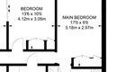
Archived estate agent floor plan for Pennybourne, 99, Sunton.
- Bedrooms
- 3
- Type
- Semi-detached
- Council tax band
- D
- Plot size
- 910 square metres (9,795 square feet) - map showing freehold boundary lines
Archived listings

Planning applications
- Planning ref:
- April 2012 E/2012/0290/TCA
- Type:
- Tree and hedge works
- Status:
- Application approved with conditions
- Address:
- Pennybourne 99 Sunton Collingbourne Ducis
- Description:
- Ash trees (T1 & T2) - fell Ash tree (T3) - removal of one limb
- Planning ref:
- December 2008 K/59730/TR2
- Type:
- Tree and hedge works
- Status:
- Application approved with conditions
- Address:
- Pennybourne 99 Sunton Collingbourne Ducis Marlborough Wiltshire
- Description:
- The felling of two ash trees, one cherry tree and three multi stemmed sycamore trees at the property, and the removal of a limb from another ash tree.
Frequently asked questions
According to HM Land Registry price paid data, Pennybourne, 99 Sunton last sold for
£360,000 in
October 2006.
The bedroom count is shown as 3 bedrooms. Bedroom numbers can come from a previous estate agency listing, an EPC record, or an estimate based on the size of the property.
When we last checked, Pennybourne, 99 Sunton was in council tax band D.
Council Tax bands can change, so check the latest
Valuation Office Agency Council Tax list.
Pennybourne, 99 Sunton is in postcode SN8 3DZ, in Burbage.
You can also view HouseMetric's sold-price page for
Sunton, SN8 3DZ
or
analysis of the Burbage property market.
HouseMetric combines HM Land Registry price paid data, Energy Performance Certificate data and Ordnance Survey/open data.
The data were last updated 1 November 2026. Figures such as indexed values and local valuation ranges are calculated estimates for context, while official records can change as public datasets are updated.
For more detail on HouseMetric data sources, update frequency and valuation methods, see the HouseMetric FAQs.