1, Waxwing Way, DN37 9HS
1 Waxwing Way is a semi-detached home in Grimsby. It sold for £127,000 in December 2008. The Land Registry and EPC data was last updated 4 August 2026.
Property data
- Sale history
-
£127,000 on Dec 2008 (est. today's value: £211,936)
- Floor plan
-
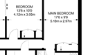
Archived estate agent floor plan for 1, Waxwing Way.
- Bedrooms
- 3
- Type
- Semi-detached
- Council tax band
- C
- Plot size
- 255 square metres (2,745 square feet) - map showing freehold boundary lines
Archived listings

Planning applications
- Planning ref:
- June 2022 DM/0383/22/TPO
- Type:
- Tree and hedge works
- Status:
- Application approved with conditions
- Address:
- Rear Of 1 Waxwing Way Adjacent To Osprey Drive Great Coates North East Lincolnshire
- Description:
- Proposal: T3 Sycamore 11m M Good Twin stem at c.5m, hosts small diameter deadwood in the canopy. The tree has been damaged in the storms. Reduce the whole tree to sound timber leaving no scars to 8m in height. T4 Sycamore 12m M Good Historic stem damage, overhangs garden, twin stemmed at c2m. Girdled roots, overhanging fence. Branches close to the fabric of the house, No. 1 Waxwing Way, old pruning wounds. Cut back lion tailed branches to boundary level Tip back overhang to boundary line, this will remove 10% of the side of the canopy encroaching the garden.
Frequently asked questions
According to HM Land Registry price paid data, 1 Waxwing Way last sold for
£127,000 in
December 2008.
The bedroom count is shown as 3 bedrooms. Bedroom numbers can come from a previous estate agency listing, an EPC record, or an estimate based on the size of the property.
When we last checked, 1 Waxwing Way was in council tax band C.
Council Tax bands can change, so check the latest
Valuation Office Agency Council Tax list.
1 Waxwing Way is in postcode DN37 9HS, in Grimsby.
You can also view HouseMetric's sold-price page for
Waxwing Way, DN37 9HS
or
analysis of the Grimsby property market.
HouseMetric combines HM Land Registry price paid data, Energy Performance Certificate data and Ordnance Survey/open data.
The data were last updated 4 August 2026. Figures such as indexed values and local valuation ranges are calculated estimates for context, while official records can change as public datasets are updated.
For more detail on HouseMetric data sources, update frequency and valuation methods, see the HouseMetric FAQs.