14, Tilton Street, SW6 7LP
14 Tilton Street is a 90 m² / 969 sq ft terraced home in Parsons Green. It sold for £510,000 in July 2009. Indexed forward to today's value, that sale is roughly £902k. Recent local prices imply a broad valuation context of £789k to £1,013k based on its internal area. The Land Registry and EPC data was last updated 1 November 2026.
- Sale history
-
Date Paid price Annual growth After inflation Jul 2009 £510,000 5.5% 3.1% Oct 2003 £375,000 na na - Floor plan
-
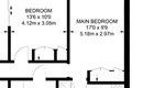
Archived estate agent floor plan for 14, Tilton Street.
- Internal area
- 90 square metres (969 square feet) according to latest EPC inspection
- Price per internal area
-
This property sold for £5,666 per square metre (£526 per square foot) in Jul 2009. Indexed forward to today's value, this is roughly £10,025 per square metre (£931 per square foot) .
Date Paid price Paid £/sqm Today's value Today's value £/sqm Jul 2009 £510,000 £5,667 £902,292 £10,025 Oct 2003 £375,000 £4,167 £1,115,657 £12,396 Calculated using the latest EPC internal area of 90 m². Earlier sale dates may not have had the same measured area available.
- Valuation
- The most recent sale price indexed forward to today's value is £902,292. This is one data point to inform the valuation. Another method is the valuation implied by what comparable homes are selling for. Homes in Parsons Green are now selling for between £8,770 and £11,260 per square metre (£814 and £1,046 per square foot). Based on an internal area of 90 m², this implies a valuation between £789,000 and £1,013,000. Treat this as context only. For a valuation using hand-picked comparable sales, use the Advanced search tool — create a shortlist of similar condition homes, then export a valuation report.
- Bedrooms
- 3
- Type
- Terrace
- Council tax band
- F
- Plot size
- 95 square metres (1,023 square feet) - map showing freehold boundary lines

- Planning ref:
- December 2009 2009/02508/FUL
- Type:
- Full and householder planning application
- Status:
- Application approved
- Address:
- 14 Tilton Street Londo
- Description:
- Erection of a rear roof extension, and installation of two rooflights in the existing front roof slope; erection of a ground floor rear extension.
- Summary:
- 03 November 2008 - energy performance certificate grade E
- Certificate:
- View energy certificate on GOV.UK
- Reason for EPC:
- rental (private)
- Tenure:
- Unknown
- Property type:
- Mid-Terrace House , has 4 habitable rooms. Estimated year built None to None
- Area:
- 90 sqm (969 square foot) total internal area
- Comments:
- Walls: Solid brick, as built, no insulation (assumed). Roof: Pitched, no insulation (assumed). Heating: Boiler and radiators, mains gas.
14 Tilton Street is worth whatever price a willing buyer and seller agree upon. However, the following can provide useful context.
- HouseMetric estimates the most recent sale price indexed forward to today's value is £902,292.
- Based on an internal area of 90 m² and recent prices in Parsons Green, this implies a lower and upper quartile range from £789,000 to £1,013,000, using HouseMetric's implied valuation methodology.
For more detail on HouseMetric data sources, update frequency and valuation methods, see the HouseMetric FAQs.