19, High Street, ME6 5AF
19 High Street is a 75 m² / 807 sq ft flat in Snodland. It sold for £180,000 in May 2021. Indexed forward to today's value, that sale is roughly £192k. Recent local prices imply a broad valuation context of £260k to £335k based on its internal area. The Land Registry and EPC data was last updated 8 October 2026.
- Sale history
-
£180,000 on May 2021
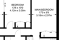
- Floor plan
-
Archived estate agent floor plan for 19, High Street.
- Internal area
- 75 square metres (807 square feet) according to latest EPC inspection
- Price per internal area
-
This property sold for £2,400 per square metre (£223 per square foot) in May 2021. Indexed forward to today's value, this is roughly £2,553 per square metre (£237 per square foot) .
Date Paid price Paid £/sqm Today's value Today's value £/sqm May 2021 £180,000 £2,400 £191,506 £2,553 Calculated using the latest EPC internal area of 75 m². Earlier sale dates may not have had the same measured area available.
- Valuation
- The most recent sale price indexed forward to today's value is £191,506. This is one data point to inform the valuation. Another method is the valuation implied by what comparable homes are selling for. Homes in Snodland are now selling for between £3,470 and £4,470 per square metre (£322 and £415 per square foot). Based on an internal area of 75 m², this implies a valuation between £260,000 and £335,000. Treat this as context only. For a valuation using hand-picked comparable sales, use the Advanced search tool — create a shortlist of similar condition homes, then export a valuation report.
- Bedrooms
- na
- Type
- Flat
- Council tax band
- na

- Planning ref:
- July 2018 18/00755/RD
- Type:
- Outline application - proposal prior to a full application, including assessments and scoping opinions.
- Status:
- Application approved
- Address:
- 19 - 21 High Street Snodland Kent
- Description:
- Details of condition 2 (materials) pursuant to planning permission TM/17/01946/FL (Change of use of 21 High Street from a vacant bank (Class A2) to create a Class A5 Hot Food Takeaway unit on the ground floor with associated external alterations, including the installation of new aluminium grilles associated with extraction and ventilation equipment, cold room compressors, and associated ancillary works, and creation of a residential flat (Class C3) on the first floor incorporating the demolition of first floor structures to create external terrace) as amended by 18/00195/NMA (Non Material Amendment to planning permission TM/17/01946/FL: Proposed alteration to external elevation and additional window to rear elevation)
- Planning ref:
- July 2018 18/00195/NMA
- Type:
- Amendments or alterations arising from an existing or previous application
- Status:
- Application approved
- Address:
- 19 - 21 High Street Snodland Kent
- Description:
- Alterations to doors and windows, additional roof lights and internal alteration to porch (Non material amendment to application 17/00415/FUL)
- Planning ref:
- June 2018 18/01250/NMA
- Type:
- Amendments or alterations arising from an existing or previous application
- Status:
- Application approved
- Address:
- 19 - 21 High Street Snodland Kent
- Description:
- Non-material amendment to application 17/00334/HP for Single storey kitchen/day lounge extension at rear and new porch at front to replace approved 3 windows in new porch with one window and to replace other windows to front elevation.
- Planning ref:
- March 2018 18/00113/AT
- Type:
- Unknown type
- Status:
- Application approved
- Address:
- 19 - 21 High Street Snodland Kent
- Description:
- External signs advertising the business occupying the premises; 1 no. Fascia Sign and 1 no. Projecting Sign
- Planning ref:
- December 2017 17/01946/FL
- Type:
- Full and householder planning application
- Status:
- Application approved
- Address:
- 19 - 21 High Street Snodland Kent
- Description:
- Change of use of 21 High Street from a vacant bank (Class A2) to create a Class A5 Hot Food Takeaway unit on the ground floor with associated external alterations, including the installation of new aluminium grilles associated with extraction and ventilation equipment, cold room compressors, and associated ancillary works, and creation of a residential flat (Class C3) on the first floor incorporating the demolition of first floor structures to create external terrace
- Planning ref:
- September 2015 15/02496/AT
- Type:
- Unknown type
- Status:
- Application approved
- Address:
- 19 - 21 High Street Snodland Kent
- Description:
- New NatWest branded illuminated ATM surround to existing ATM
- Summary:
- 21 September 2018 - energy performance certificate grade D
- Certificate:
- View energy certificate on GOV.UK
- Reason for EPC:
- marketed sale
- Tenure:
- Owner-occupied
- Property type:
- 1st floor flat on the top floor in an apartment block with 1 storeys , has 5 habitable rooms. Estimated year built 1950 to 1966
- Area:
- 75 sqm (807 square foot) total internal area
- Comments:
- Walls: Cavity wall, with internal insulation. Roof: Flat, no insulation (assumed). Heating: Boiler and radiators, mains gas.
19 High Street is worth whatever price a willing buyer and seller agree upon. However, the following can provide useful context.
- HouseMetric estimates the most recent sale price indexed forward to today's value is £191,506.
- Based on an internal area of 75 m² and recent prices in Snodland, this implies a lower and upper quartile range from £260,000 to £335,000, using HouseMetric's implied valuation methodology.
For more detail on HouseMetric data sources, update frequency and valuation methods, see the HouseMetric FAQs.