7, Maes Awel, SA65 9QZ
7 Maes Awel is a 89 m² / 958 sq ft detached home in Fishguard. It sold for £190,000 in July 2026. Indexed forward to today's value, that sale is roughly £185k. Recent local prices imply a broad valuation context of £165k to £243k based on its internal area. The Land Registry and EPC data was last updated 8 October 2026.
- Sale history
-
Date Paid price Annual growth After inflation Jul 2026 £190,000 3.0% 0.1% Nov 2013 £130,000 na na - Floor plan
-
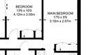
Archived estate agent floor plan for 7, Maes Awel.
- Internal area
- 89 square metres (958 square feet) according to latest EPC inspection
- Price per internal area
-
This property sold for £2,134 per square metre (£198 per square foot) in Jul 2026. Indexed forward to today's value, this is roughly £2,076 per square metre (£193 per square foot) .
Date Paid price Paid £/sqm Today's value Today's value £/sqm Jul 2026 £190,000 £2,135 £184,777 £2,076 Nov 2013 £130,000 £1,461 £216,273 £2,430 Calculated using the latest EPC internal area of 89 m². Earlier sale dates may not have had the same measured area available.
- Valuation
- The most recent sale price indexed forward to today's value is £184,777. This is one data point to inform the valuation. Another method is the valuation implied by what comparable homes are selling for. Homes in Fishguard are now selling for between £1,850 and £2,730 per square metre (£171 and £253 per square foot). Based on an internal area of 89 m², this implies a valuation between £165,000 and £243,000. Treat this as context only. For a valuation using hand-picked comparable sales, use the Advanced search tool — create a shortlist of similar condition homes, then export a valuation report.
- Bedrooms
- 2
- Type
- Detached
- Council tax band
- D
- Plot size
- 384 square metres (4,133 square feet) - map showing freehold boundary lines

- Summary:
- 02 December 2022 - energy performance certificate grade E
- Certificate:
- View energy certificate on GOV.UK
- Reason for EPC:
- None of the above
- Tenure:
- Owner-occupied
- Property type:
- Detached Bungalow , has 3 habitable rooms. Estimated year built 1983 to 1990
- Area:
- 89 sqm (958 square foot) total internal area
- Comments:
- Walls: Cavity wall, as built, insulated (assumed). Roof: Pitched, 200 mm loft insulation. Heating: Boiler and radiators, LPG.
- Summary:
- 26 July 2013 - energy performance certificate grade E
- Certificate:
- View energy certificate on GOV.UK
- Reason for EPC:
- marketed sale
- Tenure:
- Owner-occupied
- Property type:
- Detached Bungalow , has 3 habitable rooms. Estimated year built 1991 to 1995
- Area:
- 69 sqm (743 square foot) total internal area
- Comments:
- Walls: Timber frame, as built, insulated (assumed). Roof: Pitched, 300+ mm loft insulation. Heating: Boiler and radiators, LPG.
7 Maes Awel is worth whatever price a willing buyer and seller agree upon. However, the following can provide useful context.
- HouseMetric estimates the most recent sale price indexed forward to today's value is £184,777.
- Based on an internal area of 89 m² and recent prices in Fishguard, this implies a lower and upper quartile range from £165,000 to £243,000, using HouseMetric's implied valuation methodology.
For more detail on HouseMetric data sources, update frequency and valuation methods, see the HouseMetric FAQs.