49, Catfoot Lane, NG4 4QF
49 Catfoot Lane is a detached home in Gedling. It sold for £520,000 in September 2026. The Land Registry and EPC data was last updated 1 November 2026.
Property data
- Sale history
-
Date Paid price Annual growth After inflation Sep 2026 £520,000 4.1% 0.5% Aug 2017 £360,000 5.1% 2.8% Apr 2006 £206,000 na na - Floor plan
-
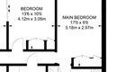
Archived estate agent floor plan for 49, Catfoot Lane.
- Bedrooms
- 3
- Type
- Detached
- Council tax band
- D
- Plot size
- 614 square metres (6,609 square feet) - map showing freehold boundary lines
Archived listings

EPC Inspections
- Summary:
- 03 August 2016 - energy performance certificate grade D
- Certificate:
- View energy certificate on GOV.UK
- Reason for EPC:
- marketed sale
- Tenure:
- Owner-occupied
- Property type:
- Detached Bungalow , has 4 habitable rooms. Estimated year built 1930 to 1949
- Area:
- 83 sqm (893 square foot) total internal area
- Comments:
- Walls: Cavity wall, as built, no insulation (assumed). Roof: Pitched, 300 mm loft insulation. Heating: Boiler and radiators, mains gas.
Frequently asked questions
According to HM Land Registry price paid data, 49 Catfoot Lane last sold for
£520,000 in
September 2026.
The bedroom count is shown as 3 bedrooms. Bedroom numbers can come from a previous estate agency listing, an EPC record, or an estimate based on the size of the property.
The latest EPC rating shown by HouseMetric is D, from an inspection dated 03 August 2016.
EPC information comes from the public Energy Performance Certificate data for England and Wales.
When we last checked, 49 Catfoot Lane was in council tax band D.
Council Tax bands can change, so check the latest
Valuation Office Agency Council Tax list.
49 Catfoot Lane is in postcode NG4 4QF, in Gedling.
You can also view HouseMetric's sold-price page for
Catfoot Lane, NG4 4QF
or
analysis of the Gedling property market.
HouseMetric combines HM Land Registry price paid data, Energy Performance Certificate data and Ordnance Survey/open data.
The data were last updated 1 November 2026. Figures such as indexed values and local valuation ranges are calculated estimates for context, while official records can change as public datasets are updated.
For more detail on HouseMetric data sources, update frequency and valuation methods, see the HouseMetric FAQs.