1, Burncroft, NE46 2EN
1 Burncroft is a 141 m² / 1,518 sq ft semi-detached home in Hexham. It sold for £380,000 in August 2026. Indexed forward to today's value, that sale is roughly £375k. Recent local prices imply a broad valuation context of £344k to £502k based on its internal area. The Land Registry and EPC data was last updated 1 November 2026.
- Sale history
-
Date Paid price Annual growth After inflation Aug 2026 £380,000 4.2% 0.7% Jun 2016 £249,950 1.0% -1.2% Nov 2005 £225,000 16.5% 14.6% Jul 2002 £133,750 15.2% 13.4% Feb 1998 £72,000 na na - Floor plan
-
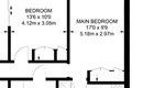
Archived estate agent floor plan for 1, Burncroft.
- Internal area
- 141 square metres (1,518 square feet) according to latest EPC inspection
- Price per internal area
-
This property sold for £2,695 per square metre (£250 per square foot) in Aug 2026. Indexed forward to today's value, this is roughly £2,657 per square metre (£247 per square foot) .
Date Paid price Paid £/sqm Today's value Today's value £/sqm Aug 2026 £380,000 £2,695 £374,651 £2,657 Jun 2016 £249,950 £1,773 £342,481 £2,429 Nov 2005 £225,000 £1,596 £318,458 £2,259 Jul 2002 £133,750 £949 £329,722 £2,338 Feb 1998 £72,000 £511 £283,376 £2,010 Calculated using the latest EPC internal area of 141 m². Earlier sale dates may not have had the same measured area available.
- Valuation
- The most recent sale price indexed forward to today's value is £374,651. This is one data point to inform the valuation. Another method is the valuation implied by what comparable homes are selling for. Homes in Hexham are now selling for between £2,440 and £3,560 per square metre (£226 and £330 per square foot). Based on an internal area of 141 m², this implies a valuation between £344,000 and £502,000. Treat this as context only. For a valuation using hand-picked comparable sales, use the Advanced search tool — create a shortlist of similar condition homes, then export a valuation report.
- Bedrooms
- 3
- Type
- Semi-detached
- Council tax band
- D
- Plot size
- 245 square metres (2,637 square feet) - map showing freehold boundary lines

- Summary:
- 05 June 2025 - energy performance certificate grade D
- Certificate:
- View energy certificate on GOV.UK
- Reason for EPC:
- marketed sale
- Tenure:
- Owner-occupied
- Property type:
- Enclosed End-Terrace House , has 6 habitable rooms. Estimated year built before 1900
- Area:
- 141 sqm (1,518 square foot) total internal area
- Comments:
- Walls: Sandstone or limestone, as built, no insulation (assumed). Roof: Pitched, no insulation (assumed). Heating: Boiler and radiators, mains gas.
- Summary:
- 19 May 2009 - energy performance certificate grade D
- Reason for EPC:
- None
- Tenure:
- Owner-occupied
- Property type:
- None , has 5 habitable rooms. Estimated year built 1900 to 1929
- Area:
- 176 sqm (1,894 square foot) total internal area
- Comments:
1 Burncroft is worth whatever price a willing buyer and seller agree upon. However, the following can provide useful context.
- HouseMetric estimates the most recent sale price indexed forward to today's value is £374,651.
- Based on an internal area of 141 m² and recent prices in Hexham, this implies a lower and upper quartile range from £344,000 to £502,000, using HouseMetric's implied valuation methodology.
For more detail on HouseMetric data sources, update frequency and valuation methods, see the HouseMetric FAQs.