73a, Ridgewood Drive, CH61 8RF
73a Ridgewood Drive is a 64 m² / 689 sq ft flat in Wirral. It sold for £85,000 in August 2026. Indexed forward to today's value, that sale is roughly £85k. Recent local prices imply a broad valuation context of £162k to £220k based on its internal area. The Land Registry and EPC data was last updated 1 November 2026.
- Sale history
-
Date Paid price Tenure Annual growth After inflation Aug 2026 £85,000 * Leasehold 5.4% 2.5% Aug 2026 £75,000 * Leasehold na na Oct 2011 £39,000 Freehold na na *This price paid record has been flagged by Land Registry as a 'Category B: Additional Price Paid entry'. This could be due to a variety of reasons, such as the sale being a buy-to-let purchase, a repossession or a transfer to a limited company. When Land Registry suspects that a sale does not reflect full market value (e.g. part-ownership or right to buy), these transactions can be flagged as well. For this reason, we exclude them from our area statistics.
- Floor plan
-
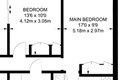
Archived estate agent floor plan for 73a, Ridgewood Drive.
- Internal area
- 64 square metres (689 square feet) according to latest EPC inspection
- Price per internal area
-
This property sold for £1,171 per square metre (£109 per square foot) in Aug 2026. Indexed forward to today's value, this is roughly £1,327 per square metre (£123 per square foot) .
Date Paid price Paid £/sqm Today's value Today's value £/sqm Aug 2026 £85,000 £1,328 £84,927 £1,327 Aug 2026 £75,000 £1,172 £74,935 £1,171 Oct 2011 £39,000 £609 £65,357 £1,021 Calculated using the latest EPC internal area of 64 m². Earlier sale dates may not have had the same measured area available.
- Valuation
- The most recent sale price indexed forward to today's value is £84,927. This is one data point to inform the valuation. Another method is the valuation implied by what comparable homes are selling for. Homes in Wirral are now selling for between £2,530 and £3,440 per square metre (£235 and £319 per square foot). Based on an internal area of 64 m², this implies a valuation between £162,000 and £220,000. Treat this as context only. For a valuation using hand-picked comparable sales, use the Advanced search tool — create a shortlist of similar condition homes, then export a valuation report.
- Bedrooms
- na
- Type
- Flat
- Council tax band
- B

- Summary:
- 24 October 2022 - energy performance certificate grade D
- Certificate:
- View energy certificate on GOV.UK
- Reason for EPC:
- marketed sale
- Tenure:
- Owner-occupied
- Property type:
- 1st floor flat on the top floor in an apartment block with 1 storeys , has 3 habitable rooms. Estimated year built 1930 to 1949
- Area:
- 64 sqm (689 square foot) total internal area
- Comments:
- Walls: Cavity wall, as built, no insulation (assumed). Roof: Pitched, 250 mm loft insulation. Heating: Boiler and radiators, mains gas.
73a Ridgewood Drive is worth whatever price a willing buyer and seller agree upon. However, the following can provide useful context.
- HouseMetric estimates the most recent sale price indexed forward to today's value is £84,927.
- Based on an internal area of 64 m² and recent prices in Wirral, this implies a lower and upper quartile range from £162,000 to £220,000, using HouseMetric's implied valuation methodology.
For more detail on HouseMetric data sources, update frequency and valuation methods, see the HouseMetric FAQs.