1, Barwell Road, IP33 1AF
1 Barwell Road is a 159 m² / 1,711 sq ft terraced home in Bury St Edmunds. It sold for £525,000 in September 2026. Indexed forward to today's value, that sale is roughly £523k. Recent local prices imply a broad valuation context of £452k to £647k based on its internal area. The Land Registry and EPC data was last updated 1 November 2026.
- Sale history
-
Date Paid price Annual growth After inflation Sep 2026 £525,000 1.4% -2.1% Jul 2016 £455,000 7.2% 5.1% Sep 2009 £282,500 -1.8% -4.2% May 2006 New build New £300,000 na na - Floor plan
-
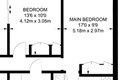
Archived estate agent floor plan for 1, Barwell Road.
- Internal area
- 159 square metres (1,711 square feet) according to latest EPC inspection
- Price per internal area
-
This property sold for £3,301 per square metre (£307 per square foot) in Sep 2026. Indexed forward to today's value, this is roughly £3,292 per square metre (£306 per square foot) .
Date Paid price Paid £/sqm Today's value Today's value £/sqm Sep 2026 £525,000 £3,302 £523,411 £3,292 Jul 2016 £455,000 £2,862 £535,336 £3,367 Sep 2009 £282,500 £1,777 £484,096 £3,045 May 2006 £300,000 £1,887 £482,243 £3,033 Calculated using the latest EPC internal area of 159 m². Earlier sale dates may not have had the same measured area available.
- Valuation
- The most recent sale price indexed forward to today's value is £523,411. This is one data point to inform the valuation. Another method is the valuation implied by what comparable homes are selling for. Homes in Bury St Edmunds are now selling for between £2,840 and £4,070 per square metre (£263 and £378 per square foot). Based on an internal area of 159 m², this implies a valuation between £452,000 and £647,000. Treat this as context only. For a valuation using hand-picked comparable sales, use the Advanced search tool — create a shortlist of similar condition homes, then export a valuation report.
- Bedrooms
- 7
- Type
- Terrace
- Council tax band
- D
- Plot size
- 168 square metres (1,808 square feet) - map showing freehold boundary lines

- Summary:
- 19 August 2024 - energy performance certificate grade C
- Certificate:
- View energy certificate on GOV.UK
- Reason for EPC:
- marketed sale
- Tenure:
- Owner-occupied
- Property type:
- End-Terrace House , has 7 habitable rooms. Estimated year built 2003 to 2006
- Area:
- 159 sqm (1,711 square foot) total internal area
- Comments:
- Walls: Cavity wall, as built, insulated (assumed). Roof: Pitched, 300 mm loft insulation. Heating: Boiler and radiators, mains gas.
- Summary:
- 12 March 2009 - energy performance certificate grade C
- Reason for EPC:
- None
- Tenure:
- Owner-occupied
- Property type:
- None , has 7 habitable rooms. Estimated year built 2003 to 2006
- Area:
- 157 sqm (1,690 square foot) total internal area
- Comments:
1 Barwell Road is worth whatever price a willing buyer and seller agree upon. However, the following can provide useful context.
- HouseMetric estimates the most recent sale price indexed forward to today's value is £523,411.
- Based on an internal area of 159 m² and recent prices in Bury St Edmunds, this implies a lower and upper quartile range from £452,000 to £647,000, using HouseMetric's implied valuation methodology.
For more detail on HouseMetric data sources, update frequency and valuation methods, see the HouseMetric FAQs.